
Class 6 Geography: Locating Places on Earth | Q&A, MCQ & MP3 Guide
CLASS ORB.COM | Teacher: Om Sikarwar
CLASS 6 — SOCIAL SCIENCE (GEOGRAPHY)
CHAPTER 1 — Locating Places on the Earth
Complete Study Notes | MCQs | Short & Long Answer Questions
For CBSE & State Board Students
| Topics Covered | 10 Topic-wise Sections |
| MCQ Questions | 15 Multiple Choice Questions |
| Short Answer Qs | 8 Questions (approx. 35 words each) |
| Long Answer Qs | 4 Questions (approx. 60 words each) |
| Language | British English | Language | British English |
| Instution | classorb.com |
| Teacher | Om Sikarwar |
TOPIC 1 — WHAT IS A MAP?
Imagine visiting a city for the first time. How would you find the places you wish to visit? You might ask a local resident for help, or you might consult a MAP! A map does exactly what a helpful friend does — it shows you the way.
MAP — Simple Definition
– A map is a representation or drawing of an area as seen from above (a bird’s-eye view).
– It may show a small area (a village, a town) or a very large area (India, the whole world).
– Maps help us understand distances, directions, and the features of a place.
ATLAS
An atlas is a book or collection of maps. When many maps are bound together in one book, it is called an Atlas.
Types of Maps
| Type of Map | | What Does It Show? | Example |
| Physical Map | Natural features — mountains, rivers, oceans | Map of the Himalayas or the River Ganga |
| Political Map | States, boundaries, cities, and capitals | Map of India showing all States and Union Territories |
| Thematic Map | Specific information on a particular topic | Rainfall map, crop distribution map |
The Three Main Components of a Map
Distance + Direction + Symbols = A Perfect Map!
1. DISTANCE — shows how far apart two places are on the map (using scale).
2. DIRECTION — shows which way is North, South, East or West.
3. SYMBOLS — small signs or drawings that represent buildings, roads, rivers, etc.
TOPIC 2 — SCALE
India is an enormous country, yet its map fits onto a single page of a book. This is possible because of the map’s SCALE.
What Is Scale?
– Scale = the ratio between a distance on the map and the actual distance on the ground.
– Example: If the scale is 1 cm = 500 m, then 1 centimetre on the map represents 500 metres on the ground.
– For a map of India, 1 cm may represent 500 km on the ground.
– The smaller the scale, the larger the area that can be shown on the map.
Remember: To find the actual distance between two points on a map, always use the scale provided.
TOPIC 3 — DIRECTION
Every map has an arrow marked with the letter ‘N’, which points towards North. Once you know North, all other directions become easy to identify.
Cardinal Directions (The Four Main Directions)
| Direction | Hindi Name | Position on Map |
| Direction | Hindi Name | Position on Map |
| NORTH (N) | Uttar | Top |
| SOUTH (S) | Dakshin | Bottom |
| EAST (E) | Purv | Right |
| WEST (W) | Pashchim | Left |
Intermediate Directions
– NE = North-East (between North and East)
– SE = South-East (between South and East)
– SW = South-West (between South and West)
– NW = North-West (between North and West)
Memory Trick!
Never Eat Soggy Waffles = North, East, South, West (going clockwise)
TOPIC 4 — SYMBOLS (Map Signs)
It would be impossible to draw every building and feature in its true form on a map — there simply is not enough space. Instead, map-makers use SYMBOLS to represent features.
| Symbol / Abbreviation | What It Represents |
| Symbol | Abbreviation | What It Represents |
| PO | Post Office | |
| PTO | Post and Telegraph Office | |
| Blue wavy lines | River or water body | |
| Double parallel lines | Road or Highway | |
| Railway track pattern | Railway Line | |
| Temple symbol | Place of worship (Temple) | |
| Church symbol | Place of worship (Church) | |
| PS | Police Station |
The Survey of India has established a standard set of symbols for maps of India, ensuring that the same symbol carries the same meaning throughout the country.
TOPIC 5 — THE GLOBE AND MAPPING THE EARTH
The Earth is not flat — it is roughly spherical in shape. Representing a sphere accurately on a flat sheet of paper is not possible. This is why we use a GLOBE
What Is a Globe?
– A globe is a sphere on which a map of the Earth is drawn.
– Because the Earth itself is spherical, a globe represents it far more accurately than a flat map.
– A globe is generally made of metal, plastic, or cardboard.
– Both latitudes and longitudes are clearly visible on a globe.
Think about this: If you peel an orange and try to flatten the pieces of skin onto a table, they will tear at the edges. This is exactly the problem with representing a sphere on a flat surface.
TOPIC 6 — COORDINATES
Coordinates are a pair of numbers (or measurements) that together pinpoint the exact location of any place on Earth. Think of it as a precise address system — just as you might say ‘the 7th shop in the 5th row of a market’, coordinates tell us exactly where a place is on the globe.
Coordinates = Latitude + Longitude
– Two values together identify any location on Earth with precision.
– Example: New Delhi = 29 degrees North latitude, 77 degrees East longitude.
– With these two values, anyone can locate Delhi on any map or globe in the world!
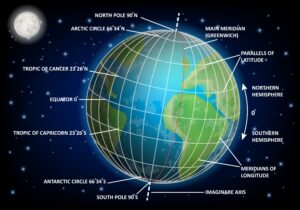
TOPIC 7 — LATITUDE
Latitude measures the distance of a place from the Equator, expressed in degrees. Lines of latitude run from east to west and are called Parallels of Latitude.
**Key Facts About Latitude**
– The Equator is 0 degrees latitude — the longest latitude line
– The North Pole is at 90 degrees N
– The South Pole is at 90 degrees S
– As you move away from the Equator towards the poles, latitude increases
– All parallels of latitude run parallel to the Equator
– The circles grow smaller as they approach the poles
Latitude and Climate
| Climate Zone | Location | Climate |
| Climate Zone | Location | Climate |
| Torrid Zone (Hot) | Near the Equator (low latitudes) | Very hot throughout the year |
| Temperate Zone (Moderate) | Middle latitudes | Neither too hot nor too cold |
| Frigid Zone (Cold) | Near the Poles (high latitudes) | Very cold throughout the year |
TOPIC 8 — LONGITUDE
Longitude measures the distance of a place from the Prime Meridian, expressed in degrees. Lines of longitude run from the North Pole to the South Pole and are called Meridians of Longitude.
Key Facts About Longitude
– The Prime Meridian = 0 degrees longitude, passing through Greenwich, London
– In 1884, nations agreed to adopt the Greenwich Meridian as the international standard
– Longitude extends from 0 degrees to 180 degrees West and 0 degrees to 180 degrees East
– New Delhi = approx. 77 degrees E | New York = approx. 74 degrees W | Tokyo = approx. 140 degrees E
– 180 degrees W and 180 degrees E are the same meridian, simply noted as 180 degrees
Important Distinction!
– Latitude lines (Parallels) = complete circles — they vary in size (Equator is the largest).
– Longitude lines (Meridians) = half-circles from pole to pole — all equal in length.
– The Equator divides the Earth into Northern and Southern Hemispheres.
– The Prime Meridian divides the Earth into Eastern and Western Hemispheres.
Did You Know? — Ujjain’s Ancient Prime Meridian
– Long before the Greenwich Meridian was established, ancient India had its own prime meridian!
– It was called the ‘Madhya Rekha’ (meaning ‘middle line’) and passed through Ujjain (Madhya Pradesh).
– The famous astronomer Varahamihira worked there approximately 1,500 years ago.
– Indian astronomers were fully aware of the concepts of latitude, longitude, and a zero meridian.
TOPIC 9 — THE GRID
When all lines of latitude and longitude are drawn together on a globe or map, they form a GRID — a network of intersecting lines, much like the lines on a sheet of squared paper. This grid allows us to locate any place with great precision.
How to Find a Location Using the Grid
– Step 1: Find the latitude — how many degrees North or South of the Equator?
– Step 2: Find the longitude — how many degrees East or West of the Prime Meridian?
– Step 3: Combine both values — this gives the exact coordinates of the place.
– Example: New Delhi = 29 degrees N latitude, 77 degrees E longitude
TOPIC 10 — TIME ZONES
Have you ever wondered why it is daytime in India whilst it is night-time in the United States of America? This is because of TIME ZONES!
How Is Local Time Calculated?
– The Earth completes one full rotation in 24 hours
– A full rotation = 360 degrees, so in one hour the Earth rotates 15 degrees (360 / 24 = 15)
– Therefore, for every 15 degrees of longitude, the time difference is 1 hour
– Moving eastwards — time increases; moving westwards — time decreases
Standard Time vs Local Time
A country cannot operate on many different local times simultaneously. Therefore, each country adopts a single Standard Time based on a central meridian.
Indian Standard Time (IST)
– IST = Indian Standard Time
– IST is 5 hours and 30 minutes ahead of Greenwich Mean Time (GMT + 5:30)
– India’s Standard Meridian = 82.5 degrees E longitude
– This meridian passes through Mirzapur, Uttar Pradesh
– When it is 12:00 noon in London (GMT), it is 17:30 (5:30 pm) in India
The International Date Line
– Located approximately at 180 degrees longitude — directly opposite the Prime Meridian
– When crossing from east to west, you add one day to the date
– When crossing from west to east, you subtract one day from the date
– The line is not perfectly straight — it curves to avoid splitting a single country into two different calendar days
– Some large countries (such as the USA and Russia) have multiple time zones
Class 6 Geography: Locating Places on Earth MULTIPLE CHOICE QUESTIONS (MCQs)
(The correct answer is shown after each question)
Q1. A book or collection of maps is called a __________.
(A) Globe (B) Atlas (C) Scale (D) Grid
Answer: (B) Atlas
Q2.The three main components of a map are __________.
(A) Scale, Globe, Grid (B) Distance, Direction, Symbols (C) Latitude, Longitude, Time (D) North, South, East, West
**Answer: (B) Distance, Direction, Symbols**
Q3. The latitude of the Equator is __________.
(A) 90 degrees N (B) 45 degrees S (C) 0 degrees (D) 180 degrees
Answer: (C) 0 degrees
Q4. The Prime Meridian passes through __________.
(A) Paris, France (B) New York, USA (C) New Delhi, India (D) Greenwich, London
Answer: (D) Greenwich, London
Q5. Indian Standard Time (IST) is ahead of GMT by __________.
(A) 5 hours (B) 5 hours 30 minutes (C) 6 hours (D) 4 hours 30 minutes
Answer: (B) 5 hours 30 minutes
Q6. The latitude of the North Pole is __________.
(A) 45 degrees N (B) 0 degrees (C) 90 degrees N (D) 180 degrees N
Answer: (C) 90 degrees N
Q7. How many degrees of longitude does the Earth rotate in one hour?
(A) 10 degrees (B) 24 degrees (C) 15 degrees (D) 360 degrees
Answer: (C) 15 degrees
Q8. The International Date Line is located approximately at __________.
(A) 0 degrees longitude (B) 90 degrees E (C) 45 degrees W (D) 180 degrees longitude
Answer: (D) 180 degrees longitude
Q9. Lines of latitude are also called __________.
(A) Meridians (B) Parallels (C) Grid lines (D) Scale lines
Answer: (B) Parallels
Q10. A globe is __________.
(A) A flat map (B) A measurement of scale (C) A sphere on which a map of the Earth is drawn (D) A page from an atlas
Answer: (C) A sphere on which a map of the Earth is drawn
Q11. India’s Standard Meridian passes through __________.
(A) New Delhi (B) Mirzapur (82.5 degrees E) (C) Mumbai (D) Chennai
Answer: (B) Mirzapur (82.5 degrees E)
Q12. In map directions, ‘SE’ stands for __________.
(A) South-West (B) North-East (C) South-East (D) North-West
Answer: (C) South-East
Q13. Symbols are used on maps in order to __________.
(A) Make the map more colourful (B) Show numerous features within a limited space (C) Calculate distances (D) Show the scale
Answer: (B) Show numerous features within a limited space
Q14. Lines of longitude run from __________.
(A) East to West (B) Equator to Tropic (C) North Pole to South Pole (D) Prime Meridian to International Date Line
Answer: (C) North Pole to South Pole
Q15. In ancient India, the prime meridian passed through __________.
(A) New Delhi (B) Varanasi (C) Ujjain (D) Agra
Answer: (C) Ujjain
SHORT ANSWER TYPE QUESTIONS Class 6 Geography: Locating Places on Earth (Approximately 35 Words)
Q1. What is a map? What is an atlas?
A map is a representation or drawing of an area as seen from above. It may depict a small locality or the entire world. Maps help us understand distances, directions, and geographical features. A collection of maps bound together in a single book is called an atlas.
Q2. What is scale? Why is it important in map-making?
Scale is the ratio between a distance measured on a map and the corresponding actual distance on the ground. For example, 1 cm = 500 km. Scale allows vast areas to be shown on a small sheet of paper, making maps practical and useful.
Q3. What are cardinal directions?
Cardinal directions are the four principal directions — North, South, East, and West. On a map, an arrow marked ‘N’ indicates North, from which all other directions can be determined. Intermediate directions include North-East, South-East, South-West, and North-West.
Q4. What is latitude? What is the Equator?
Latitude is the angular distance of a place north or south of the Equator, expressed in degrees. Lines of latitude are called parallels. The Equator is the 0-degree latitude line — the longest parallel that divides the Earth into the Northern and Southern Hemispheres.
Q5. What is the Prime Meridian?
The Prime Meridian is the 0-degree longitude line, which passes through Greenwich, London. It was adopted as the international standard in 1884. The Prime Meridian divides the Earth into the Eastern and Western Hemispheres, and all longitudes are measured from it.
Q6. What is the difference between local time and standard time?
Local time is calculated according to a specific longitude, whereas standard time is a single time adopted by an entire country based on a chosen meridian. India’s Standard Time (IST) is GMT + 5 hours 30 minutes, based on the 82.5 degrees E meridian passing through Mirzapur.
Q7. What is the International Date Line?
The International Date Line lies approximately at 180 degrees longitude, directly opposite the Prime Meridian. Crossing it changes the date — moving eastward subtracts one day; moving westward adds one day. It follows a slightly curved path to avoid dividing countries into two different calendar days.
Q8. Why are symbols necessary on a map?
Maps have limited space, so it is impossible to draw every building or feature in its actual form. Symbols — such as PO for Post Office and blue lines for rivers — allow numerous features to be displayed within a small area. The Survey of India provides standard symbols for Indian maps.
Class 6 Geography: Locating Places on Earth Long Q&A MCQ & MP3 Guide (Approximately 60 Words)
Q1. What is a map? Describe its types and the three main components.
A map is a representation or drawing of any area as viewed from above. It may depict a small area, such as a village or a vast area, such as the entire world. A collection of maps is called an atlas.
Maps are of three main types:
1. Physical Maps — show natural features such as mountains, rivers, and oceans.
2. Political Maps — show countries, states, boundaries, and cities.
3. Thematic Maps — provide specific information such as rainfall or crop distribution.
Every map has three essential components: Distance (shown through scale), Direction (indicated by a North arrow), and Symbols (signs representing various features). Together, these components make a map accurate, readable, and highly useful.
Q2. What are latitude and longitude? How do coordinates help us locate places?
Latitude is the angular distance of a place north or south of the Equator, measured in degrees. Lines of latitude are called parallels. The Equator (0 degrees) is the longest parallel, whilst the North Pole (90 degrees N) and South Pole (90 degrees S) are the extremes.
Longitude is the angular distance of a place east or west of the Prime Meridian (0 degrees, Greenwich, London), also measured in degrees. Lines of longitude are called meridians and run from pole to pole.
Together, latitude and longitude form coordinates — a precise system for locating any place on Earth. For example, New Delhi lies at approximately 29 degrees N latitude and 77 degrees E longitude. With these two values, Delhi can be pinpointed on any globe or map in the world.
Q3. What are time zones? Explain IST and the International Date Line.
The Earth completes one full rotation of 360 degrees in 24 hours, which means it rotates 15 degrees per hour. Every 15 degrees of longitude, therefore, represents a difference of one hour in local time. These divisions of time are called time zones.
Local Time: the time calculated for a specific longitude.
Standard Time: the official time adopted by an entire country based on a selected meridian.
Indian Standard Time (IST) = GMT + 5 hours 30 minutes, based on the 82.5 degrees E meridian through Mirzapur, Uttar Pradesh. When it is 12:00 noon in London, it is 17:30 in India.
The International Date Line lies approximately at 180 degrees longitude. Crossing it from west to east subtracts one calendar day; crossing from east to west adds one day. Large countries such as Russia and the USA have multiple time zones.
Q4. What is a globe? Why is it a more accurate representation of the Earth than a flat map?
A globe is a sphere on which a map of the Earth is drawn. It may be made of metal, plastic, or cardboard and clearly shows the network of latitudes, longitudes, continents, and oceans.
A flat map cannot accurately represent a spherical surface. When we attempt to flatten a sphere — as when peeling an orange and pressing the pieces flat — the pieces tear and distort. Similarly, flat maps distort the shapes and sizes of countries, especially near the poles.
Advantages of a globe over a flat map:
1. Distances are represented accurately.
2. Shapes and sizes of countries are not distorted.
3. Latitudes and longitudes are clearly visible.
4. The relative positions of continents are correctly shown.
For these reasons, a globe provides a far more reliable and accurate picture of the Earth than any flat map.
CHAPTER SUMMARY — Quick Revision
Term | Meaning
|-
Map – A drawing or representation of an area as seen from above
Atlas – A book or collection of maps
Scale – Ratio of map distance to actual distance on the ground
Cardinal Points- North, South, East, West — the four main directions
Symbols – Signs used on maps to represent features and landmarks
Globe – A sphere on which a map of the Earth is drawn
Latitude – Angular distance north or south of the Equator, in degrees
Equator – 0 degrees latitude — the longest parallel of latitude
Parallels – Lines of latitude running east to west
Longitude – Angular distance east or west of the Prime Meridian, in degrees
Prime Meridian – 0 degrees longitude — passes through Greenwich, London
Meridians: Lines of longitude running from pole to pole |
Coordinates – Latitude + Longitude together pinpoint any location on Earth
Grid – Network of latitudes and longitudes drawn together
Local Time – Time calculated for a specific longitude | IST | Indian Standard Time = GMT + 5 hours 30 minutes
GMT – Greenwich Mean Time — the time at 0 degrees longitude (London)
International Date Line – Approx. 180 degrees longitude — crossing it changes the date
Time Zone – Every 15 degrees of longitude = 1 hour time difference
Torrid Zone – Hot climate zone near the Equator
Temperate Zone – Moderate climate zone in middle latitudes || Frigid Zone | Cold climate zone near the Poles
To Download HINDI Medium PDF, CLICK HERE
To Download English Medium PDF, CLICK HERE